
What is the most accurate way to survey land? There are many ways to survey land, like with a theodolite, total station or with GPS. But what is the most accurate. That answer I will give in this article.
What is the most accurate way to survey land? With a the total station if used correctly you can get millimeter accuracy. But main concern with the accuracy of a total station is the accuracy of the base points. If those are determined with GPS then the accuracy of a land survey with a total station won’t be better than the one with GPS.
To explain you more about this topic I will answer you some more questions on this topic:
- What are the most accurate land survey methods?
- How does land surveying with a total station work?
- How does land surveying with GPS work?
- What is the most accurate way to land survey?
What is the most accurate way to survey land? Quick solution
One accurate way to land survey is with GPS. And the best software to land survey with GPS is Apglos Survey Wizard. If you want to try this land survey app then you can download Apglos Survey Wizard on the Play Store.
Apglos Survey Wizard is free to try. Because after registration you get 2500 coins for free that you can use in this land survey app. That is sufficient to try the complete GPS app.
But if you like Apglos Survey Wizard, and I think you will, then you can buy more coins or a time license in our webshop.
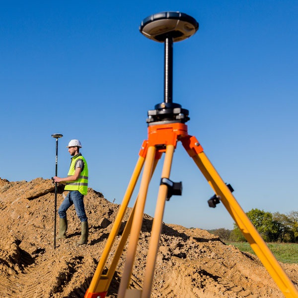
When you download this land survey app on your phone then it will first use the GPS of your phone, which is not that accurate. If you want to do an accurate land survey then you do need an external GNSS receiver. Check out this page for external GNSS receivers. They for sure work with Apglos Survey Wizard.
What are the most accurate land survey methods?
There are many different methods to survey land. But nowadays we don’t just want to know how big a plot of land is, or what the distance is between two points. We love to have coordinates of those points.
When our land survey data consists of coordinates then you can project them on a map. And a drafter or designer can use them to design something like a road.
With that in mind already lots of land survey methods can be scrapped from the list. And that means that there are only two main methods that are still in the running of what is the most accurate way to land survey.
The first method is the total station. The total station is a land surveyors instrument that used distances, angles and base points to calculate and determine coordinates. Before you needed two people to do a land survey with a total station. But nowadays there are robotic total stations that follow the prisma. So that means if you know how to work with a total station you can now do it alone.
The other method that is still in the running on what is the most accurate way to survey land is a complete GPS surveying kit.
How does land surveying with a total station work?
As I mentioned before a total station is a land surveyors instrument. It has to be placed on a building terrain on a spot where you can see all the objects that you want to survey.

But before you can start land surveying with a total station you have to map the base points. Base points are points with known coordinates. The total station measures the distance and the angle to several base points.
After doing this the total station can determine the position of all objects that are within the base points.
To do so a land surveyor goes with a prisma to an object and puts a rod with a prisma on top on the object that needs to be surveyed. The total station measures than the distance and the angle to the prisma.
Because the total station stored the coordinates, distances and angles of the base points it can calculate the coordinate of the objects that are surveyed.
You can see a total station as a big automatic calculator that keeps on calculation coordinates based on the distances and angles it measures. If everything is done correctly then the accuracy of a total station is just a few millimeters.
So when you look at a total station like that then you will see that a total station is a wonderful instrument for land surveyors.
But it is not my favorite. I prefer a GPS surveying kit, because that is so much easier to work with.
How does land surveying with GPS work?
GPS also works very different. Also in a GNSS receiver, which is part of a GPS surveying kit a lot of calculation goes on, but it has nothing to do with angles.
The GNSS receiver receives satellite signals. The satellite signals have information on when the signal got sent and from where it got sent. When a GNSS receiver receives enough satellite signals then it can determine a global position on earth. This position can be more exact when the GNSS receiver is used stationary.
But most of the time you move around with a GNSS receiver. That makes that the GNSS receiver can’t determine its exact position.
The GNSS receiver uses the speed of the satellite signal to calculate the position of the GNSS receiver. And because of the atmosphere the speed of the signal is not always the same.
That is why the GNSS receiver needs to compare the data of the received satellite signals with the date that it receives from a stationary GNSS receiver.
Since a stationary GNSS receiver does not move it can determine its exact position after a period. And after that it can determine what is the variation in speed of the satellite signal through the atmosphere. The stationary GNSS receiver then can send those corrections to GNSS receivers in the field.
This stationary GNSS receiver can be a single base or part of a CORS network.
The GNSS receiver you are using for land surveying objects can receive those corrections by radio or through the internet. And after receiving those it can determine its position much more accurate.
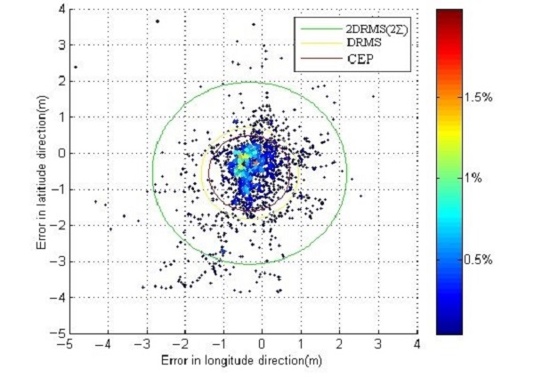
The best accuracy you can get with a complete GPS surveying kit is around 1 centimeter. And that is very well for a system that depends on satellites that are more than 20000 km above us.
What is the most accurate way to land survey?
Now if you read till here you will think that the total station is more accurate than a complete GPS surveying kit. And if you only look at the instrument you are correct.
But there is a big thing to consider. This thing is the way the base points are determined.
Usually there are not enough benchmarks close to the location where you would like to use the total station. This means most of the time the base points that are used for land surveying with a total station are determined with GPS.
And that changes things a lot. If the base points have centimeter accuracy, because of using GPS, then the other points you are surveying can’t have a better accuracy than the accuracy of the base points.
That means that a total station in most cases does not have a better accuracy than a complete GPS surveying kit. The best accuracy that a total station can get is the same accuracy as a GPS surveying kit.
Conclusion of “What is the most accurate way to land survey?”
The total station instrument can deliver the most accurate results in land surveying. But to get those results you have to do everything correct. The most important thing is to determine your base points well.
But if you use GPS to determine the base points then the total station and the GPS surveying kit will have the same kind of accuracy.
When you then have to chose between a total station and a GPS surveying kit, you should look at other things. The first one is the ease of use. And a GPS surveying kit is much easier to work with. The main reason for that is the GPS surveying software.
The best GPS surveying app in the matter of ease of use is Apglos Survey Wizard.
You can download it in the Google Play Store. It is free to try. Of course if you want to use Apglos Survey Wizard more then you can always buy more coins or a time license in our webshop.
And if you want to land survey with high accuracy then you also need an external GNSS receiver. You can find more about external GNSS receivers here.