AUSGeoid is a geoid. And when you are GPS surveying you need a geoid. If you use the wrong geoid then the height results you get from your land survey will be wrong. Let’s see how you prevent that.
What is AUSGeoid? It is a geoid that is used in Australia to calculate the level to Australian Height Datum from a GPS coordinate. The most recent geoid in Australia is AUSGeoid2020. That is the one you should use. Fortunately this AUSGeoid2020 is already integrated in land survey app Apglos Survey Wizard.
To explain you more about this topic I will answer you some more questions on this topic:
- What is AUSGeoid?
- Is AUSGeoid the same as AHD (Australian Height Datum)?
- What is the difference between AUSGeoid2020 and AUSGeoid09?
- What geoid model should you use?
- How to configure Apglos Survey Wizard to use AUSGeoid2020?
Try AUSGeoid in Apglos Survey Wizard! Quick solution
AUSGeoid2020 and AUSGeoid09 are both integrated in Apglos Survey Wizard. So if you want to see the difference in the results of both geoids then you should try both geoid files in Apglos Survey Wizard. If you want to try this land survey app then you can download Apglos Survey Wizard on the Play Store.
Apglos Survey Wizard is free to try. Because after registration you get 2500 coins for free that you can use in this land survey app. That is sufficient to try the complete GPS app.
But if you like Apglos Survey Wizard, and I think you will, then you can buy more coins or a time license in our webshop.
Of course if you want to have a real comparison between the two geoids then you need an accurate position. To get an accurate position with GPS you need an external GNSS receiver. Check out this page for external GNSS receivers. They for sure work with Apglos Survey Wizard.
What is AUSGeoid?
To answer this question I need to tell you some background of land surveying. Before there was GPS the land surveyors were surveying in northing and easting. Every coordinate had a northing and an easting. And of course there was a height as well for every coordinate.
When GPS was introduced land surveying changed a lot. When you land survey with GPS you get a coordinate on a sphere, the earth. That coordinate has to be projected on a map. There are all different calculations for that. Every country has their own calculation to transform the GPS coordinate to a coordinate with northing and easting.
The problem is that if you take the 3rd dimension of the GPS coordinate then you don’t get the correct elevation.
We all learnt that water flows downwards. But if you use the elevation calculated from GPS coordinates that is not always the case. Because the gravity on earth is not equal. So it means that only based on GPS coordinates water can flow upwards.
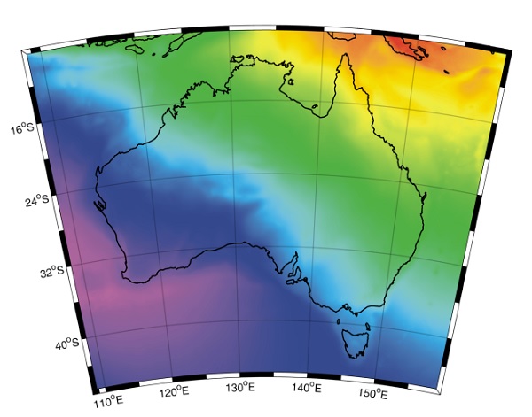
That is why this 3rd part of the coordinate needs to be corrected. And that is done by a geoid. The geoid that they use in Australia is AUSGeoid followed by a number that indicates the year.
Is AUSGeoid the same as AHD (Australian Height Datum)?
AHD is the Australian Height Datum. It is the height level of Australia. And to be short AUSGeoid is not the same as AHD.
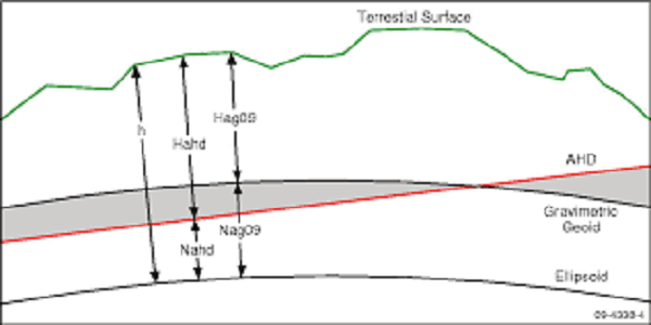
But AUSGeoid and AHD are related. At least when you are using GPS. A GPS coordinate gives the height to the ellipsoid. This you can also call orthometric height.
But you don’t want the height to the ellipsoid you want the height different to a vertical level that everyone in that region agreed on. In Australia this is AHD.
So to get the height to AHD you have to calculate it from the GPS coordinate in combination with the data from AUSGeoid.
What is the difference between AUSGeoid2020 and AUSGeoid09?
I already mentioned that a geoid gives the height difference from the used ellipsoid to a vertical level that everyone agreed on. This vertical level in Australia is AHD.
But the height only has some value when there is a reference in northing and easting. In Australia they use different ellipsoids. These are GDA94 and GDA2020. GDA94 uses reference frame ITRF92. And GDA2020 uses reference frame ITRF2014.
ITRF is a spatial reference system that rotates together with the earth in its daily rotations. ITRF makes sure there are no horizontal movements of points on the earths surface except for movements caused by tectonic and tidal deformations.
ITRF92 uses the year 1984 as the base time of the situation of the earths surface. You can imagine that at this moment the earths surface might have moved a bit. That is why you can use in Australia GDA2020 that has the reference frame ITRF2020. This reference frame uses the situation of the earths surface of 2010. So that is 26 years later than ITRF92.
In this time period there has been horizontal movement of the earths surface. The gravity field of earth usually moves together with the earths surface. That means if you use the new GDA2020 ellipsoid with IRTF2020 as a reference frame the height to AHD won’t be calculated correct if you use AUSGeoid09. The reason for this is that AUSGeoid09 is based on GDA94 with the reference frame ITRF92.
The two used reference frames for one point are incorrect. If you use them together you might get an error of 9 centimeters in height.
What geoid model should you use?
The geoid model you have to use depends on the ellipsoid you are using. If you use GDA94 then you should use the geoid AUSGeoid09. And if you use GDA2020 then you should use AUSGeoid2020.
Only then you know for sure that you use the same reference frame for as well the calculation to a northing and easting as for the calculation of the height to AHD.
Most of the time the best use of practice is to use to most recent data, which is the ellipsoid GDA2020 in combination with AUSGeoid2020.
How to configure Apglos Survey Wizard to use AUSGeoid2020?
Of course you can use these settings in land survey app Apglos Survey Wizard. To do so you go to the File menu and click on Other Settings.
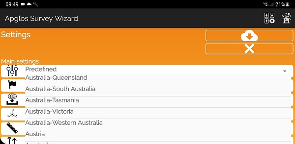
On the new screen you select your region in Australia. Then you select GDA2020 as the ellipsoid. And then you select the coordinate reference system that you want to use with AUSGeoid2020 as the geoid to be used.
In the video above you can see how that is done.
Conclusion of “What is AUSGeoid?”
AUSGeoid is a geoid of Australia. It is used to calculate the correct height to Australian Height Datum. There are different versions of AUSGeoid, like AUSGeoid2020 and AUSGeoid09. The correct one you have to use depends on the ellipsoid you are using to get your GPS coordinates.
Of course you can use both geoids in Apglos Survey Wizard. You can download it in the Google Play Store. It is free to try. Of course if you want to use Apglos Survey Wizard more then you can always buy more coins or a time license in our webshop.
And if you want to land survey with high accuracy then you also need an external GNSS receiver. You can find more about external GNSS receivers here.