
Trimble is a big company in the land surveying world. The company is huge, but what is Trimble all about? Read it all here
![]()
Trimble the company
Trimble is active in lots of different industries. So it is not only a company in the land surveying world. Most fields they work in are related to land surveying though. Because they are working in the following industries:
- agriculture
- building construction
- civil engineering
- construction
- geospatial
- transportation
- forestry
- rail
- field service management
- telecommunications
- electric and water utilities
As you can see all these fields are related with land surveying or positioning. What Trimble wants to do is to connect the physical world with the digital world. This they do by delivering products and services to do so.
Besides that is it the reason that their core technology is about positioning, modeling, connectivity and data analytics. Their core technology is special, because they have over 2000 worldwide patents. So they have a big research and development team that continues to develop.
The history of Trimble
Trimble started in 1978. Mr. Charlie Trimble and two others employees of Hewlett-Packerd started it at that time. And they didn’t know exactly in what world they were going to conquer.
The goal of them was to develop innovative positioning and navigation products. Innovative makes sense because the company had its first office in Silicon Valley.
In the same year the first GPS satellite was launched. And the rise of the use of GPS went together with the growth of Trimble. Charlie Trimble was very interested in GPS and kept on developing on this terrain.
That is why in 1982 Trimble could launch their first products using GPS technology. One of the first products with this technology was marine navigation. In 1984 they got their first patent and they started to grow more. The reason that they gre rapidly was that they were buying other companies.
And they kept acquiring other companies. This made it easy for them to make their access to new markets. Besides that they kept on developing. That is how Trimble developed in 1992 the Real-Time Kinematic (RTK) technology. Because of RTK you can now land survey without having to do post processing tasks.
Another victory for Trimble was that they were the first to put GPS and cellular communications on a single board. This happened in 1998.
After that they focussed on growth. They bought many companies, like Spectra Geospatial, Advanced Public Safety, Apache Technologies and many more. We guess they didn’t finish. To keep updated on this information check this companies website.
The GNSS receivers of Trimble
Trimble R2
The GNSS receivers of this company are produced in the R series. That is why the names of all their GNSS receivers start with ‘R’. It is kind of useful since this company has many other products other than GNSS receivers. Anyway the first GNSS receiver is the R2.
There are no really specific things to notify when you see this GNSS receiver. But let’s see how the specifications are. Because of the history of the company the specifications of this GNSS receiver should be well.
- Dimensions: 140x140x114 mm
- Weight: 1080 gram
- Ingress protection: IP65
- Corrections: CMR, CMR+, CMRx, RTCM2, RTCM3
- Position output: NMEA, GSOF
- Positioning kinematic horizontal: 10 mm + 1 ppm
- Positioning kinematic vertical: 20 mm + 1 ppm
- GNSS signals tracked: GPS L1, L2, GLONASS L1, L2, BEIDOU B1, B2, GALILEO E1, E5b
- Number of channels: 220
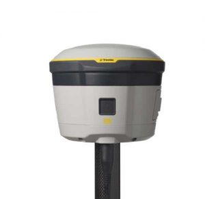
R8S
Of course there are newer versions than the R2. There is still development in the GPS world. And that makes this company also to create new GNSS receivers. One receiver that is newer than the R2 is the R8S.

This GNSS receiver already has the no known colors of Trimble. The GNSS receivers that they produced after this one also have the same color style with white on top, a little bright yellow edge and light grey on the bottom. That is how you can recognize it. But if it is a good GNSS receiver you can see better in the specifications.
- Dimensions: 190x190x104 mm
- Weight: 1520 gram
- Ingress protection: IP67
- Corrections: CMR, CMR+, CMRx, RTCM2, RTCM3
- Position output: NMEA, GSOF, RT17, RT27
- Positioning kinematic horizontal: 8 mm + 0.5 ppm
- Positioning kinematic vertical: 15 mm + 0.5 ppm
- GNSS signals tracked: GPS L1, L2, L5, GLONASS L1, L2, L3, BEIDOU B1, B2, GALILEO E1, E5a, E5b
- Number of channels: 440
As you can see it has better specifications than the R2. But the size and weight of this GNSS receiver are huge. Nowadays there are complete GPS kits that almost have a lower weight than this GNSS receiver. If you want to know more about that then check out this page.
R10
Of course this company didn’t stop with the R8S. After that they launched a new GNSS receiver. This was the R10.
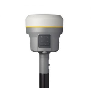
You can see that the same color combination of the R8S is comning back in this GNSS receiver. So let’s check the specifications on how well this GNSS receiver is.
- Dimensions: 119x119x136 mm
- Weight: 1120 gram
- Ingress protection: IP67
- Corrections: CMR+, CMRx, RTCM2, RTCM3
- Position output: NMEA, GSOF, RT17, RT27, PPS
- Positioning kinematic horizontal: 8 mm + 0.5 ppm
- Positioning kinematic vertical: 15 mm + 0.5 ppm
- GNSS signals tracked: GPS L1, L2, L5, GLONASS L1, L2, L3, BEIDOU B1, B2, B3, GALILEO E1, E5a, E5b, E5 AltBoc, E6
- Number of channels: 672
Trimble R12
And then there is the R12.
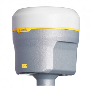
It has the same stylish color combination as the R8S and the R10. So the specifications make the difference.
- Dimensions: 119x119x136 mm
- Weight: 1120 gram
- Ingress protection: IP67
- Corrections: CMR+, CMRx, RTCM2, RTCM3
- Position output: NMEA, GSOF, RT17, RT27
- Positioning kinematic horizontal: 8 mm + 0.5 ppm
- Positioning kinematic vertical: 15 mm + 0.5 ppm
- GNSS signals tracked: GPS L1, L2, L5, GLONASS L1, L2, L3, BEIDOU B1, B2, B3, GALILEO E1, E5a, E5b, E5 AltBoc, E6
- Number of channels: 672
Trimble surveying software
The trick of Trimble is to make a closed system. That is why standard the output of their GNSS receivers is not NMEA. They have their own output formats RT17 and RT27. Their own software like Penmap can read and use these output formats, while third party software has problems reading and using this output formats. But for their GNSS receivers Trimble can open NMEA output.
That means you can work with the easiest land survey app Apglos Survey Wizard with the GNSS receivers of Trimble. If you want to know what Apglos Survey Wizard can do for you then please check this page. It is easier than for example Penmap and you can try it for free. You can read more about the software Penmap here.
Besides Penmap Trimble launched also other software packages like:
- Terraflex
- TerraSync
- SiteVision
- Site Controller Software
- Pathfinder
So Trimble has lots of software packages. But none of their packages are as easy as Apglos Survey Wizard. Check the ease of use of this software out on this page.